

Geocam Free

คำอธิบายของGeocam Free
Geocam by Wazar is the leading geophoto and video application for Android. It uses augmented reality to show on top of your camera a layer of geographical information such as Compass orientation, GPS position and different phone inclinations like a theodolite optical instrument.
What you can do with Geocam:
* Geo-Pictures: photos that have an extra layer of geographical data such as GPS position, compass orientation, pitch, roll, altitude, etc. This data is added into the EXIF metadata and can selectively be drawn on images as an overlay. You can see all you pictures on Google Maps or on Google Earth on your personal computer with the export feature. You can share those albums with anyone who can run Google Earth.
* Geo-Videos (Pro only): the first and only app to let you record videos with an embed layer of geographical data. A useful addition to pictures. With Geocam Studio (available on geocam.wazar-apps.com), customize and export these videos and share them.
* Bearings: Geocam is an accurate measure tool. It shows your compass orientation (choose between magnetic or geographic North), your inclination and elevation with readable cursors (like a cockpit HUD). It can be used in terrain mapping, on a glide, sailing, mountain biking...
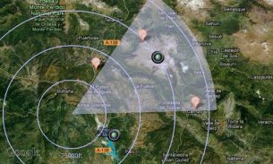
* Geo-Caching: prepare a list of key places in an area and view them with your camera on augmented reality: name, distance. You will not require a data connection offline so it can be used when hiking abroad, when visiting another city... This will help you make sure you are going in the right direction and give you remaining distance. You can also add markers during your hike with the "Add here" option, for example to flag the base camp, a water source, or anything interesting you find on your way.
* Measurements: Evaluate the distance to any object with the triangulation feature. You can also measure its height once the distance is known. This is not done by showing any unreadable cursor on the screen, but with mathematical formulas. Choose between metric and imperial measure systems.
Geocam supports extensive customisation including:
* Selecting which indicators to display on the HUD and whether to save them or not on pictures
* Metric and imperial systems
* GPS Formats: Decimal degrees, degrees/minutes/second, MGRS, UTM
* True north or magnetic north
* Degrees or Mils compass readings
* Percentage or degree slopes
* Calibrating "zero" pitch and roll to custom values to measure differences
* Different themes including a "cockpit" style or a "hi-vis" style
This is a free edtition, and with Geocam Pro, you get:
* No Ads
* Record and playback augmented video. This is a powerful tool in addition to Geophoto to record the topology of any area for further reference, as you can add your own audio commentary. Augmented video is an exclusivity of Geocam by Wazar.
* Export KMZ files to Google Earth, to display your pictures and markers in their original location and orientation, and share them easily.
IMPORTANT NOTE: If you are facing an issue, we cannot help you if you only leave a review. Do get it touch by email so we can hep you. We do reply to all emails and regularly push out fixes to reported problems. By all means please do get in touch if you are experiencing difficulties.
Geocam โดย Wazar เป็นโปรแกรม geophoto และวิดีโอชั้นนำสำหรับ Android โดยจะใช้ความเป็นจริงยิ่งที่จะแสดงอยู่ด้านบนของกล้องของคุณชั้นของข้อมูลทางภูมิศาสตร์เช่นการวางแนวทางเข็มทิศตำแหน่ง GPS และความโน้มเอียงโทรศัพท์ที่แตกต่างกันเช่นตราสารแสงกล้องสำรวจ
คุณสามารถทำอะไรกับ Geocam:
* Geo-รูปภาพ: ภาพถ่ายที่มีชั้นพิเศษของข้อมูลทางภูมิศาสตร์เช่นตำแหน่งจีพีเอปฐมนิเทศเข็มทิศขว้างสูง ฯลฯ ข้อมูลนี้จะถูกเพิ่มเข้าไปในเมตาดาต้า EXIF และสามารถเลือกที่จะวาดภาพเป็นภาพซ้อนทับ คุณสามารถดูทั้งหมดภาพบน Google Maps หรือ Google Earth บนคอมพิวเตอร์ส่วนบุคคลของคุณด้วยคุณสมบัติการส่งออก คุณสามารถแบ่งปันอัลบั้มผู้ที่มีทุกคนที่สามารถเรียกใช้ Google Earth
* Geo-วิดีโอ (Pro เท่านั้น): แอปแรกและคนเดียวที่จะช่วยให้คุณสามารถบันทึกวิดีโอที่มีชั้นฝังจากข้อมูลทางภูมิศาสตร์ ยังมีประโยชน์ให้กับรูปภาพ ด้วย Geocam สตูดิโอ (ตาม geocam.wazar-apps.com) ปรับแต่งและการส่งออกวิดีโอเหล่านี้และแบ่งปันให้
* แบริ่ง: Geocam เป็นเครื่องมือวัดที่ถูกต้อง มันแสดงให้เห็นการวางแนวทางของเข็มทิศ (เลือกระหว่างแม่เหล็กหรือทางภูมิศาสตร์ภาคเหนือ), ความชอบและความสูงของคุณกับเคอร์เซอร์ที่อ่านได้ (เช่นห้องนักบิน HUD) มันสามารถนำมาใช้ในการทำแผนที่ภูมิประเทศบนเหิน, เรือใบ, ปั่นจักรยานเสือภูเขา ...
* ภูมิศาสตร์แคช: เตรียมรายชื่อของสถานที่สำคัญในพื้นที่และดูพวกเขามาพร้อมกับกล้องของคุณในความเป็นจริงยิ่ง: ชื่อระยะทาง คุณจะไม่จำเป็นต้องมีการเชื่อมต่อข้อมูลแบบออฟไลน์เพื่อที่จะสามารถนำมาใช้เมื่อเดินป่าในต่างประเทศเมื่อเข้าสู่เมืองอื่น ... นี้จะช่วยคุณให้แน่ใจว่าคุณจะไปในทิศทางที่ถูกต้องและให้ระยะทางที่เหลือ นอกจากนี้คุณยังสามารถเพิ่มเครื่องหมายระหว่างธุดงค์ของคุณด้วย "เพิ่มที่นี่" ตัวเลือกเช่นธงค่าย, แหล่งน้ำหรืออะไรที่น่าสนใจที่คุณพบในแบบของคุณ
* การวัด: การประเมินระยะทางที่วัตถุใด ๆ ที่มีคุณสมบัติสม นอกจากนี้คุณยังสามารถวัดความสูงระยะทางที่ครั้งหนึ่งเคยเป็นที่รู้จักกัน นี้ไม่ได้ทำโดยการแสดงเคอร์เซอร์ไม่สามารถอ่านได้บนหน้าจอใด แต่มีสูตรทางคณิตศาสตร์ เลือกระหว่างระบบการวัดและตัวชี้วัดจักรวรรดิ
Geocam รองรับการปรับแต่งที่กว้างขวางรวมไปถึง:
* การเลือกหุ้นที่จะแสดงบนฮัดและไม่ว่าจะช่วยพวกเขาหรือไม่ได้อยู่ในภาพ
* เมตริกและระบบอิมพีเรียล
* รูปแบบ GPS: องศาทศนิยมองศา / นาที / วินาที, MGRS, UTM
* ทิศเหนือจริงหรือทิศเหนือแม่เหล็ก
* องศาหรือ Mils อ่านเข็มทิศ
* ร้อยละหรือปริญญาเนินเขา
* ปรับเทียบ "ศูนย์" สนามและม้วนให้เป็นค่าที่กำหนดเองในการวัดความแตกต่าง
* รูปแบบที่แตกต่างกันรวมทั้ง "ห้องนักบินสไตล์" หรือ "Hi-Vis สไตล์"
นี่คือ edtition ฟรีและมี Geocam Pro คุณจะได้รับ:
* ไม่มีโฆษณา
* บันทึกวิดีโอและการเล่นเติม นี้เป็นเครื่องมือที่มีประสิทธิภาพในการนอกเหนือไปจากการบันทึก Geophoto โครงสร้างของพื้นที่ใด ๆ สำหรับการอ้างอิงต่อไปในขณะที่คุณสามารถเพิ่มเสียงวิจารณ์ของคุณเอง วิดีโอ Augmented เป็นความพิเศษของ Geocam โดย Wazar
* ส่งออกไฟล์ KMZ ไปยัง Google Earth เพื่อแสดงภาพและเครื่องหมายของคุณในสถานที่เดิมของพวกเขาและการวางแนวและแบ่งปันได้อย่างง่ายดาย
หมายเหตุ: หากคุณกำลังประสบปัญหาที่เราไม่สามารถช่วยให้คุณถ้าคุณจะออกความคิดเห็น ไม่ได้รับมันสัมผัสทางอีเมลเพื่อให้เราสามารถ hep คุณ เราจะตอบอีเมลทั้งหมดและสม่ำเสมอผลักดันออกจากการแก้ไขปัญหารายงาน โดยทั้งหมดหมายความว่าโปรดอย่าได้รับการติดต่อถ้าคุณมีความยากลำบากประสบ


